

Ownmates Post

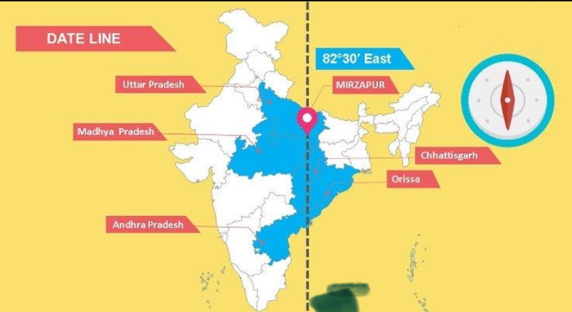
🌍 How India’s Standard Time (IST) is Derived from 82°30′ East Longitude (82.5°E)
India follows a single uniform time across its vast territory known as Indian Standard Time (IST), which is based on the 82°30′ East longitude (82.5°E). Here is a clear, detailed, and complete explanation.
1. Earth’s Rotation and Time Calculation
The Earth completes one full rotation of 360° on its axis in 24 hours.
• 360° ÷ 24 hours = 15° per hour
• Therefore, 1° of longitude = 4 minutes of time difference.
Key Rule:
• Moving east → time is ahead.
• Moving west → time is behind.
2. Calculating IST from 82.5°E
• 82.5° × 4 minutes = 330 minutes
• 330 minutes = 5 hours 30 minutes
Since this longitude is east of the Prime Meridian (0° at Greenwich, UTC), the time is ahead of UTC.
Result:
UTC 00:00 5 hours 30 minutes = IST (UTC 5:30)
Example:
When it is 12:00 noon in London (UTC), it is 5:30 PM in India.
3. Why Was 82.5°E Chosen as India’s Standard Meridian?
India needed one central longitude to serve as the reference for the entire country’s time. The 82.5°E meridian was selected because it passes roughly through the middle of India.
Main Reasons:
• It runs near Mirzapur in Uttar Pradesh.
• It provides a balanced and convenient time for the whole country.
• The value 82.5° is clean and easy to work with.
India’s Geographical Extent:
• Westernmost point: Approx. 68°7′E (Gujarat)
• Easternmost point: Approx. 97°25′E (Arunachal Pradesh)
Average (Mid-point):
(97.4 68.1) ÷ 2 ≈ 82.75°E
This is very close to 82.5°E. That is why it is described as passing through the “central part” of India. It is not the exact geometric center, but a practical and balanced choice.
4. What If Another Longitude Was Chosen?
• If 75°E was chosen:
75 × 4 = 300 minutes → UTC 5:00
→ India’s time would be 30 minutes behind current IST.
• If 90°E was chosen:
90 × 4 = 360 minutes → UTC 6:00
→ India’s time would be 30 minutes ahead of current IST.
• If the exact average 82.75°E was chosen:
Difference = 82.75° – 82.5° = 0.25°
0.25° × 4 minutes = 1 minute
IST would then be UTC 5:31 — a negligible difference. However, 82.5° is simpler and cleaner for official use.
5. What is Longitude?
Longitudes are imaginary lines running from the North Pole to the South Pole that measure position east or west of the Prime Meridian (0°).
• There are 360° of longitude in total (180° East 180° West).
• India lies roughly between 68°E and 97°E.
• Longitude is used along with latitude (north-south position) to pinpoint any location on Earth.
Uses of Longitude:
• Determining time zones
• GPS and navigation
• Aviation and maritime routes
• Mapping
6. Distance Covered by 1° of Longitude
The actual ground distance of 1° longitude varies with latitude because the Earth is spherical.
Formula:
Distance of 1° longitude = 111.3 × cos(latitude) km
• At the Equator (0°): 111.3 km
• In India (around 25°N latitude):
cos(25°) ≈ 0.906
111.3 × 0.906 ≈ 100.8 km
Conclusion: In central India, 1° of longitude ≈ 101 km.
Therefore, moving from 82.5°E to 83.5°E covers roughly 100–101 km on the ground.
Summary
The 82.5°E meridian was chosen as India’s Standard Meridian because:
• It lies near the central part of the country.
• It allows a single convenient time for the entire nation.
• The resulting time (UTC 5:30) is clean and balanced between the eastern and western extremities.
• It maintains good equilibrium between the west and east of India.
This meridian is not just a technical line — it symbolizes India’s geographical and temporal unity.🌍🕒


Comments
akhand Bharat